|
Mangrove forests, at first glance,
may seem like muddy, murky areas full of mosquitoes, other insects,
and crabs. They used to be plentiful in Anguilla but then, in the
mid- and late-1990s, this small island was hit by two powerful
hurricanes that devastated the environment and put enormous stress
on its people. Anguillians, though, were resilient and were able to
pick up the pieces and rebuild their houses and businesses. The
natural environment had to do the same. Most trees re-grew their
leaves (and branches), the water slowly drained from the land, and
the birds returned to the ponds. But even five and ten years later,
it has not recovered completely. The fragile habitats that tropical
coastal ecosystems are known for – the coral reefs, seagrass beds,
and mangrove forests – were the hardest hit and the extent and
health of them, post-hurricane, is nowhere near what they used to
be.
Already stressed by other factors
including the impacts of coastal development, the hurricanes nearly
pushed the health and integrity of the coastal habitats over the
edge. Although most attention and concerns when it comes to coastal
environments tends to be focused on the state of the island’s coral
reefs, mangrove forests cannot and should not be forgotten.
While there are over 50 species (or
types) of mangroves worldwide, buttonwood are the most common in
Anguilla. Small stands of black, white, and red mangroves, with
their long roots curving and dipping into the water are also
scattered mostly in south-central and south-east coastal areas of
the island. They thrive in areas where the land meets the water and
although they can grow into trees that are taller than 40 metres,
mangrove trees in Anguilla are much shorter because of the
conditions under which they live – relatively limited amount of
rain, a limestone-based ground, low natural soil and nutrient
content, and strong winds.
Regardless, their productivity,
however, is astounding. Reports indicate that these ecosystems can
produce over 23 tonnes of leaf litter, flowers, and branches in a
single year – all of which becomes scattered on the mangrove forest
floor. These materials are important sources of organic matter that,
in turn, provide energy and minerals to other organisms that live in
the coastal and marine environments.
Mangrove forests also act as nursery
areas for a variety of animals, including fish. They serve as a type
of safe haven where young fish are more protected than in the open
ocean (or even on the coral reefs) and where they can find a
constant food supply. Other organisms such as crabs use these
forests as hiding and feeding places. The trees’ intricate root
system, meanwhile, help to protect shorelines from erosion, serve as
sediment traps (which protect both coral reefs and seagrass beds
from being smothered and suffocated) filter contaminants and
nutrients (again, protecting coral reefs and seagrass beds from
pollution and from nutrient overload), and provide a buffer to other
coastal forests which cannot survive in salty conditions.
But they are under threat. Despite
being one of the most important habitats in the world, their
significance tends to go unappreciated. Their swamp-like qualities –
muddy, sticky, and insect-ridden – often puts them at the forefront
of environmental destruction because it is felt that they do not
provide anything useful. Seen as a good source of firewood and as
ideal places to build – they are right next to the water! – they
tend to be cut down and/or filled in with little regard to what is
lost.
One stand that was severely damaged
by Hurricane Luis (1995) and again by Hurricane Lenny (1999) was the
mixed mangrove stand found in Little Harbour. Unlike many other
areas on the island that were equally damaged, this mangrove system
has made a strong come-back. Bordering on the salt pond and
extending out to the eastern side of the bay, the mangroves are
representative of what the ecosystem should look like: they reflect
the general diversity typical of the small island. A dense stand of
red mangrove fringes three sides of the pond (the east, north, and
west) and smaller stands of black and white mangrove and buttonwood
are found on the south. While they continue to regenerate
(particularly the buttonwood) and become denser each year, their
progress is being hampered by the construction of luxury homes that
both require space and an unobstructed view. Valuable habitat for
approximately 30 different species of birds is further threatened by
such development.
|
|
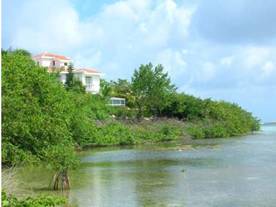
Coastal development encroaching on a mangrove stand
in Little Harbour (photo taken in July 2006). |
| |
|
|
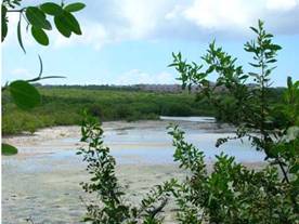
| Mixed mangrove stand in Little Harbour Pond
(photo taken in July 2006) |
| |
|
|
|
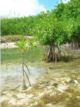
Young red mangroves in Little
Harbour Pond (photo taken in July 2006). |
| |
| |
| |
|